20141107

Emerging markets to drive investments in EO data and services: Euroconsult report

Paris, October 9, 2014

According to Euroconsult's newly published report, Satellite-Based Earth Observation: Market Prospects to 2023, 353 earth observation (EO) satellites are expected to be launched over the next decade compared to 162 over 2004-2013. The report claims that this will result in $36 billion in manufacturing revenues over the period, an 85% increase over the previous decade.

Organisations from 41 countries are expected to launch EO satellite capacity by 2023, compared to 33 over the previous decade. The report notes that supply from government continues to grow strongly as more countries expand their portfolios of EO satellites to meet various policy needs. In addition, newcomers are launching EO satellite capacity to develop a local industrial base, create the building blocks for a space program, obtain greater autonomy in data acquisition, and/or meet local demand for data and services. As a result, investment in EO and meteorology programs reached a high in 2013 at $8.7 billion, a 13% increase over 2012, the report states.


20140909

MOL’s mysteries

by Dwayne A. Day
Monday, September 8, 2014


The Air Force’s Manned Orbiting Laboratory (MOL) of the 1960s is finally being declassified. A significant document release this summer included hundreds of illustrations of the overall laboratory, many of its components and subsystems, and also proposed variants and upgrades. As a result, it is now possible to gain a good understanding of how MOL was configured and how it operated.
MOL illustration
When MOL was cancelled in summer 1969, it was a major financial blow to McDonnell Douglas.
Nevertheless, many MOL questions remain unanswered and will have to await further document declassifications or former MOL personnel discussing the program and their role in it. For example, what contractors were involved in the development of MOL and what were their roles? How did they work together, especially when some parts of the project were unclassified and some were deep black.
Because MOL was an unusual program with both unclassified and classified elements, many details about it were released while it was under development, although this conveniently helped to distort the image of what MOL was actually for. Based upon the unclassified parts alone, it is clear that MOL was a large and expensive project. In 1967, the Air Force awarded fixed-price incentive-fee contracts to Douglas Aircraft for $674.7 million and McDonnell for over $180 million. Douglas was responsible for the laboratory module’s unpressurized and pressurized sections and McDonnell for the Gemini B spacecraft. Other sources indicate that McDonnell was supposed to provide four Gemini B spacecraft with options for two or more later. Douglas signed subcontracts for such components as the waste management system, attitude control, and life support. When Douglas and McDonnell merged later that year, the combined company was responsible for a very large Department of Defense space contract. Thus, when MOL was cancelled in summer 1969 it was a major financial blow to McDonnell Douglas.

20140723

US Air Force to launch new surveillance satellites

Washington (AFP) July 23, 2014


The US Air Force will launch new satellites Wednesday to track those of other countries and counter possible threats to American spacecraft, officials said.
Two satellites are due to be sent into high-altitude orbits for the first time as part of a program that until a few months ago was strictly secret and classified.
The satellites will be launched from Delta IV rockets from Cape Canaveral Air Force Station in Florida and head to the geosynchronous belt, 22,300 miles (35,900 kilometers) above Earth, where crucial US satellites are also orbiting.
"This neighborhood watch twosome will help protect our precious assets in geo (high-altitude orbit), plus they will be on the lookout for nefarious capability other nations might try to place in that critical orbital regime," US Air Force Space Command chief General William Shelton told reporters.
Shelton said the satellites would dramatically improve the US military's picture of satellite traffic in the geosynchronous orbit, as the new satellites will be much closer at the higher altitude.
Current space surveillance is conducted from the Earth or from lower altitudes of a few hundred miles above Earth.
The project is known as the Geosynchronous Space Situational Awareness Program, or GSSAP, and was first publicly acknowledged in March.

OCO-2 Data to Lead Scientists Forward into the Past

Pasadena CA (JPL) Jul 23, 2014


Scientists will use measurements from the Orbiting Carbon Observatory-2 to track atmospheric carbon dioxide to sources such as these wildfires in Siberia, whose smoke plumes quickly carry the greenhouse gas worldwide. The fires were imaged on May 18 by NASA's Moderate Resolution Imaging Spectrometer instrument on the Terra satellite. Image courtesy NASA/LANCE/EOSDIS Rapid Response. For a larger version of this image please go here.
NASA's Orbiting Carbon Observatory-2, which launched on July 2, will soon be providing about 100,000 high-quality measurements each day of carbon dioxide concentrations from around the globe. Atmospheric scientists are excited about that. But to understand the processes that control the amount of the greenhouse gas in the atmosphere, they need to know more than just where carbon dioxide is now. They need to know where it has been. It takes more than great data to figure that out.
"In a sense, you're trying to go backward in time and space," said David Baker, a scientist at Colorado State University in Fort Collins. "You're reversing the flow of the winds to determine when and where the input of carbon at the Earth's surface had to be to give you the measurements you see now."
Harry Potter used a magical time turner to travel to the past. Atmospheric scientists use a type of computer model called a chemical transport model.
It combines the atmospheric processes found in a climate model with additional information on important chemical compounds, including their reactions, their sources on Earth's surface and the processes that remove them from the air, known as sinks.
Baker used the example of a forest fire to explain how a chemical transport model works. "Where the fire is, at that point in time, you get a pulse of carbon dioxide in the atmosphere from the burning carbon in wood. The model's winds blow it along, and mixing processes dilute it through the atmosphere. It gradually gets mixed into a wider and wider plume that eventually gets blown around the world."

Rising-2 captured highest resolution image of earth’s surface

2014/07/16
Sendai, Japan - July 4, 2014 – Microsatellite Rising-2 has succeeded in capturing high precision images of the earth’s surface. Using a High Precision Telescope (HPT), it has successfully taken color images at a spatial resolution of 5m, the highest in the world among 50kg-class satellites.
Rising-2 is a microsatellite developed by Tohoku University and Hokkaido University. It was launched from the Tanegashima Space Center, Japan, on May 24, 2014, and has been conducting various test operations. Dayside cloud imagery and night views of city lights and air glow have been acquired so far using a Wide Field-of-view CCD camera (WFC), and high resolution imaging experiments using HPT have recently started. On July 2, Rising-2 succeeded in shooting detailed landscape in sunny spells during the rainy season as shown in the following attachment.

20140721

Planetary orbit insertion failures (part 2)


by Andrew J. LePage
Monday, June 23, 2014 

Mars Observer

Mars Observer illustration
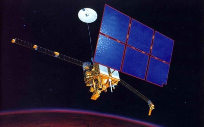
Artist concept of the Mars Observer in orbit around Mars. (credit: NASA)
Mars Observer was the first American mission to Mars since Viking was launched in 1975. It was the first in NASA’s new Planetary Observer series of missions that adapted existing spacecraft and instruments for planetary missions with the intent to keep costs low in a time of tight federal budgets. To this end, Mars Observer employed General Electric’s three-axis stabilized Satcom K communication satellite bus as well as subsystems from military and civilian polar orbiting meteorological satellites. Mars Observer’s mission was to perform a wide range of investigations of Mars using an extensive suite of instruments from a circular 350-kilometer (218-mile) orbit.
Although there are many possible causes, the consensus seems to be that Mars Observer was lost as a result of a fatal failure of the propulsion system.
After years of delays, cost overruns, and a switch from the Space Shuttle to a Commercial Titan III/TOS for launch as a result of the 1986 Challenger disaster, Mars Observer finally lifted off on September 25, 1992, and was sent on its way to Mars. In order to avoid issues encountered with the propulsion system on the Viking spacecraft during their transit to Mars, the decision had been made seven months before launch to postpone the pressurization of the propellant tanks that fed a redundant pair of 490-newton (110-pound-force) bipropellant engines to be used for major maneuvers, including the vital 28-minute, 50-second orbit insertion burn. Minor course corrections took place during the cruise to Mars in a “blow down” mode that did not require full pressurization of the system.

Big Black Bird


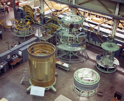
MOL components
Elements of the Manned Orbital Laboratory under construction in the 1960s. (credit: USAF)
After five decades of secrecy, the details of the 1960s-era Manned Orbiting Laboratory (MOL) program are finally being revealed.
MOL was started in late 1963 but did not get a formal approval from President Lyndon Johnson until 1965. Publicly, it was a two-person military space station program to conduct experiments to determine what military missions humans could accomplish in space.
MOL illustration

Heavy glass: The KH-10 DORIAN reconnaissance system


MOL diagram
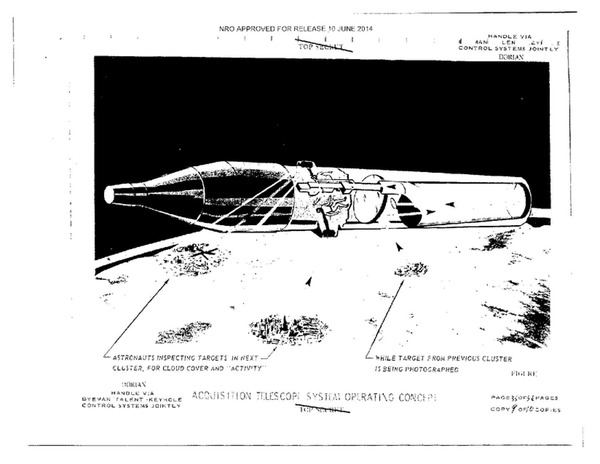
Illustration of the MOL in orbit, performing reconnaissance activities. (credit: USAF)
MOL diagram
In the mid-1960s, an American reconnaissance satellite overflew the Soviet submarine construction facility at Severodvinsk and got lucky: a Soviet submarine was out of the water, up on rails, and in plain sight, providing a rare view of its propeller. Normally when submarines are in the water their propellers are not visible, and knowing the number of blades on a propeller is useful information for knowing how fast a submarine is moving. Sonar operators on ships or other submarines can count the number of times the blades beat the water and estimate a vessel’s speed. So this photo was a real coup. Not too long after it was taken, it was used by an instructor who was then training Air Force astronauts. He showed it to them as an example of the kind of opportunities that they might find as they orbited the Earth, peering down on the Soviet Union.
Such “targets of opportunity” were a key justification for the existence of the Manned Orbiting Laboratory (MOL) program of the 1960s. Although American robotic reconnaissance satellites had been operating since August 1960, some people in the US military and intelligence communities believed that astronauts could play an important role in reconnaissance. Although MOL started out as a general-purpose experimental space station, it soon evolved into a spacecraft with an operational—and highly classified—reconnaissance mission.

ADS and Esri Take Satellite Imagery Services to a Premium Level

Paris (SPX) Jul 21, 2014


ArcGIS Online users will also be able to order Pleiades and SPOT 6 (and soon 7) archive imagery with an easy-to-use Satellite Tasking and Archive app.
Airbus Defense and Space and Esri have developed three new Premium Content Services to provide ArcGIS Online users with an option to access Pleiades and SPOT thematic imagery, customized monitoring services, and for the first time on the ArcGIS Marketplace, users can directly task Airbus Defense and Space's optical satellites online.
These services will be launched this week at the Esri International User Conference, July 14-18 in San Diego, CA.
The developments have been done under the umbrella of an agreement both companies have signed in order to provide a new level of geo-intelligence imagery and services through Esri's ArcGIS Marketplace.
The ArcGIS Marketplace is a destination where ArcGIS Online users can search, discover, and get apps and data from qualified providers for use within their organization. The Airbus Defense and Space Premium Content Services listed in the Marketplace will be available to ArcGIS users worldwide.
"We are very excited to be able to provide ArcGIS users with unprecedented access to our satellite imagery products and services," said Bernhard Brenner, Head of the Geo-Intelligence program line of Airbus Defense and Space. "Working directly with the Esri team has enabled us to develop three services we know will fit the needs of ArcGIS users. We will be providing demos at the Esri International User Conference."

20140717

DigitalGlobe Announces New Oil & Gas Offerings From Spatial Energy

Wednesday, June 18th 2014
Spatial Energy | Longmont, CO

LONGMONT, CO, Jun 18, 2014- DigitalGlobe, Inc. a leading global provider of commercial high-resolution earth observation and advanced geospatial solutions, today announced the availability of the first in a series of new commercial offerings for the energy market from recently acquired Spatial Energy.
The new DigitalGlobe Energy Suite includes online, subscription-based offerings available to enterprise oil and gas customers through Spatial on Demand, its market-leading cloud-based enterprise data management platform. The suite provides immediate access to information and insight that can be integrated with desktop workflows across the entire energy enterprise, which will become available to Spatial on Demand customers on July 1.
The first set of products in the DigitalGlobe Energy Suite includes:
Basemap +Energy
Basemap +Energy is an online living globe tailored specifically for energy customer accuracy, update, and historical needs. It is the only source of constantly updated 50 cm imagery with supporting metadata and simple download capability, making it the single source of the best available data for use by global stakeholders.

20140618

Planetary orbit insertion failures (part 1)


by Andrew J. LePage
Monday, June 16, 2014

One of the most crucial phases of many interplanetary missions is orbit insertion. Everything must go right the first time or the spacecraft fails to enter orbit around its target. And, all too often, there are no practical opportunities at a second chance, so an orbit insertion failure usually translates into a mission failure. At this moment, there are a half a dozen spacecraft en route to various targets throughout the solar system destined to enter orbit around their targets. It seems like this is a good opportunity to review orbit insertion failures over the last four decades of planetary exploration to see what can go wrong.

Akatsuki illustration
Artist concept of Akatsuki in orbit around Venus. (credit: Akihiro Ikeshita)

The commercial remote sensing boom

by Jeff Foust
Monday, June 16, 2014

A couple of years ago, the health of the commercial satellite remote sensing industry, at least in the United States, wasn’t good. Commercial interest in high-resolution images of the Earth from space wasn’t as high as the industry forecast back in the 1990s, when a new generation of companies—enabled by changes in national policy—developed satellites to serve this market. The US government had helped prop up the industry, but by 2012 the National Geospatial-Intelligence Agency (NGA) was cutting back on its purchases of commercial imagery, undermining the business cases for the two companies selling such imagery, DigitalGlobe and GeoEye (see “EnhancedView’s cloudy future”, The Space Revuew, May 7, 2012). Later that year, those two companies merged under the DigitalGlobe name.
SkySat-1 and 2
Skybox Imaging’s first two satellites, SkySat-1 and -2, in the company’s clean room. SkySat-1 is in orbit with SkySat-2 slated for launch this year. Google announced plans last week to acquire Skybox for $500 million. (credit: Skybox Imaging, Inc.)

Today, though, the sector is remarkably vibrant. While DigitalGlobe continues its approach of selling high-resolution imagery to government and commercial customers, a number of smaller startups seek a different approach though the development of constellations of smaller satellites that provide imagery more frequently. One of those startups is now on track for a significant deal as others try and enter the market, but that vibrancy doesn’t necessarily translate into long-term viability.

20140603

Secret optics

by Dwayne A. Day
Monday, June 2, 2014

When it comes to spaceflight it is easy to get lost in the technology—engines, capsules, satellites, landers, and heat shields. Too often the people who build them are overlooked or forgotten and never get the credit or the opportunity to tell their stories.
This is even worse when it comes to classified space programs, where the people involved are not allowed to discuss their involvement as long as the program remains classified and sometimes even after it has been declassified.


Pressel’s goal was to not only explain what he and his fellow engineers at Perkin-Elmer Corporation did, but also to give credit to the often brilliant and always hard-working people who toiled away in secrecy on a major project at the same time that NASA was preparing to send astronauts to the Moon.
Fortunately, this isn’t always the case. In the fall of 2011, the National Reconnaissance Office (NRO) declassified two major Cold War reconnaissance satellite programs, the GAMBIT and HEXAGON. GAMBIT, which operated from 1963 until 1984, was a high-resolution camera system that peered down on the Soviet Union taking incredibly detailed photographs. HEXAGON, which involved 19 operational satellites launched between 1971 and 1985, was powerful in two ways: it also took highly detailed photographs and had the ability to see and map, in stereo, the whole landmass of the Earth, making it impossible for America's adversaries to hide anything from sight.
The NRO released a large number of documents about both programs, including lengthy official histories (although the release of documents has essentially stopped for the past year). But even that declassified material has huge holes in it, such as detailed discussion of how the subsystems were built, who built them, and how they overcame problems during design. As one example, we know that the GAMBIT-1 (KH-7) and the GAMBIT-3 (KH-8) systems actually flew, but the released documents provide very little information on the rejected GAMBIT-2 design. Nor do the official histories reveal much about the development of HEXAGON’s immensely complex camera system, or even the spacecraft propulsion and control system that supported it in orbit.

20140529

Sentinel-1 aids Balkan flood relief

Paris (ESA) May 29, 2014


Flood delineation map over the village of Balatun in northeastern Bosnia and Herzegovina based on Sentinel-1A data. Serbia lies to the north of the Sava river. File image coourtesy ESA/European Commission. For a larger version of this image please go here.
Although not yet operational, the new Sentinel-1A satellite has provided radar data for mapping the floods in Bosnia and Herzegovina. Heavy rainfall leading to widespread flooding and landslides has hit large parts of the Balkans, killing dozens of people and leaving hundreds of thousands displaced.
Jan Kucera of the Europan Commission's Joint Research Centre is supervising the technical aspect of the Copernicus Emergency Management Service (EMS). While mapping the flooding in northeastern Bosnia and Herzegovina, ESA delivered a radar scan from Sentinel-1A: "I had a first look and discovered that we were missing an important flooded area visible in the middle of the image."
Although the radar on Sentinel-1A is still being calibrated, the new information could be integrated into the Copernicus EMS flood maps of the Sava river in the Balatun area in Bosnia and Herzegovina.
"In emergency situations like these, it is important that we optimise all the available data to produce better maps for disaster relief efforts."
The radar on Sentinel-1 is able to 'see' through clouds, rain and in darkness, making it particularly useful for monitoring floods. Images acquired before and after a flood offer immediate information on the extent of inundation and support assessments of property and environmental damage.

DLR, TBE partner for earth observation mission

Published Date : 20 May 2014
Germany: At the ILA Berlin Air Show, the German Aerospace Centre, Deutsches Zentrum für Luft- und Raumfahrt (DLR) and US-based company Teledyne Brown Engineering  (TBE) have signed an agreement to install and operate the imaging spectrometer DESIS (DLR Earth Sensing Imaging Spectrometer) on board the International Space Station (ISS). This DLR-built instrument will be one of four camera systems for remote sensing fitted to the MUSES (Multi-User System for Earth Sensing) instrument carrier. DESIS will be able to detect changes in the land surface, oceans and atmosphere; it will contribute to the development of effective measures to protect the environment and climate.
DESIS is a hyperspectral camera that records image data using an array of up to 240 closely spaced channels, covering the visible and near infrared portions of the spectrum (450 to 915 nanometres) with a ground resolution of approximately 90 metres. This multifaceted information allows scientists to detect changes in ecosystems and to make statements on the condition of forests and agricultural land.
Among other things, its purpose is to secure and improve the global cultivation of food. The data from the ISS instruments will be available quickly in the event of a catastrophe and can help rescue teams operating on the ground to organise their deployment. DLR and TBE seek to combine the data from other MUSES instruments to develop advanced methods for remote sensing of the Earth.
The platform with the DLR DESIS instrument is scheduled to commence operations in 2016.
Source:  DLR & http://geospatialworld.net

Japan launches new satellite to survey disasters by Staff Writers

Tokyo (AFP) May 24, 2014


Japan successfully launched a new mapping satellite on Saturday that will be used to survey damage from natural disasters and changes affecting rainforests.
The Advanced Land Observing Satellite-2 (ALOS-2) will be able to see scars left by catastrophes such as Japan's 2011 tsunami as well as monitor progress made in reconstruction, officials from the Japan Aerospace Exploration Agency said.
"The satellite was successfully put in orbit," said an official from Mitsubishi Heavy Industries, whose H-IIA rocket was used in the launch from a space centre on the southern island of Tanegashima.
The satellite will provide valuable data for Japan, which sits on the Pacific Ring of Fire and experiences 20 percent of all major earthquakes.
Memories are still fresh of the deadly 9.0-magnitude earthquake in March 2011 that unleashed a tsunami that devastated the northern Pacific coast, killing more than 18,000 people and triggering the Fukushima nuclear crisis.
The island nation is also routinely hit by typhoons while scientists say Mount Fuji could erupt at any time.
The new satellite, nicknamed "Daichi-2", will "conduct a health check mainly of the Earth's land areas in detail," JAXA project manager Shinichi Suzuki said.
The satellite will collect data related to deformation of the Earth's crust, but also the impact of floods and landslides, he said.
The satellite's predecessor was used to monitor damage caused by the 2011 earthquake and tsunami.
The device uses a special radar to observe the planet's surface at night, during bad weather and even through vegetation.
JAXA plans to use the new satellite to regularly study tropical rain forests, which are difficult to observe because of the thick clouds that frequently cover them. It will also be used to observe snow and ice conditions in polar areas, officials said.
source:  spacedaily.com

Airbus Defence and Space partners with BAE Systems on radar satellite imagery

Tuesday, May 20th 2014
|

New products to reach highest levels of accuracy, resolution and quality
Airbus Defence and Spaceand BAE Systemshave launched a strategic alliance to produce, market and sell innovative geospatial intelligence (GEOINT) products and solutions using state-of-the-art data collected exclusively by TerraSAR-X and TanDEM-X radar satellites.
Under the terms of the partnership, Airbus Defence and Space and BAE Systems will jointly develop a new line of global SAR (synthetic aperture radar) products that are unrivalled in terms of accuracy, resolution and quality.  The two companies will exclusively market these products to US government, commercial, and select international customers.
“BAE Systems’s unique expertise will leverage the SAR data we are collecting into refined sets of geospatial intelligence products, that meet stringent US government standards,” said Evert Dudok, Head of Communications, Intelligence & Security at Airbus Defence and Space.
The precision and richness of Airbus Defence and Space’s radar data products, combined with the rigour of BAE Systems’s GEOINT exploitation and analysis expertise, will drive the development of advanced geospatial products that will benefit both the public and private sectors. The resulting GEOINT products will enhance mission planning for defence customers, support flight systems, improve emergency response, and help the world’s energy sector strategically plan new power grids, plot pipelines and manage resources.
“The Airbus Defence and Space radar satellite missions are collecting data of unprecedented quality and accuracy on a global scale,” said DeEtte Gray, president of BAE Systems’s Intelligence & Security sector. “The products we are teaming to develop represent a major leap forward in SAR-based products and services that enhance various sophisticated applications.”

George Clooney Announces Expansion of Satellite Sentinel Project

Wednesday, May 21st 2014
| New York, NY

During a speech yesterday, May 20, at the Elie Wiesel Foundation for Humanity dinner, George Clooney announced a significant expansion of the Satellite Sentinel Project, an initiative he co-founded three years ago.  While it will continue to use satellite imagery to monitor and warn against human rights abuses in war-torn Sudan and South Sudan, the Satellite Sentinel Project will expand its focus to undertake forensic investigations to reveal how those committing mass atrocities are funding their activities and where they are hiding their stolen assets.
Satellite Sentinel Project Co-Founder George Clooney said, “We want to follow the money and find out how these atrocities are funded, who enables them, and what the smart tools are to counter these activities more effectively.  Genocide and other human rights crimes are never just spontaneous events.  They require planning, they require financing, and they require international indifference to succeed.  Where is the money coming from and where is it being hidden? To the extent we can, we want to make it more difficult for those willing to kill en masse to secure their political and economic objectives, and we want to move the needle away from indifference and inaction.”
Satellite Sentinel Project Co-Founder John Prendergast said, “We’ll investigate exactly how the illegal exploitation of resources like diamonds, gold and ivory help finance the activities of some of the world’s worst abusers of human rights.  And we’ll focus on imposing a cost on those that contribute to or facilitate the perpetration of these human rights crimes. The objective is a comprehensive approach to countering atrocities that involves satellite imagery, forensic investigations, on-the-ground research, and deeper investment in impacting the calculations of policy makers and commercial actors who might possess the leverage to help stop these human rights crimes.”

BlackBridge Secures $22 Million for New Satellite Constellation

Thursday, May 22nd 2014

BlackBridge Secures $22 Million for New Satellite Constellation
A new generation of RapidEye Satellites is underway
BlackBridge has secured $22 million (CDN) in funding from the Bank of Montreal (BMO) and the Business Development Bank of Canada (BDC) for the development of its next generation of satellites, RapidEye+, and for the renewal of existing credit facilities.  This financing will contribute to the development of a new satellite constellation that will enhance BlackBridge’s already remarkable imaging prowess, allowing the company to expand its current range of geospatial solutions.

BlackBridge CFO Richard Goode says of the investment, "We are pleased that both BMO and BDC have joined us in the development of our next generation of satellites. We are seeking strong long-term partners as we continue to grow our business, and both BMO and BDC provided the financial strength and commitment we were looking for.”

MDA expands imaging modes for RADARSAT-2

Thursday, May 22nd 2014
| Richmond BC Canada

MDA’s Information Systems group has commercially launched a unique new imaging mode for RADARSAT-2. This Extra-Fine mode provides an unprecedented ability to capture exceptional resolution imagery over large areas, providing a capability that is ideally suited to support monitoring large areas coupled with identifying detailed changes. The Extra-Fine imaging mode is able to provide single polarization synthetic aperture radar (SAR) imagery at a 5 meter resolution, over a 125 km x 125 km area (or 15,625 km2 per scene).
The RADARSAT-2 satellite has global high-resolution surveillance capabilities that include a large collection capacity and high accuracy. The satellite acquires data regardless of light or weather condition, provides frequent re-visit imaging options, and is supported by ground receiving stations that provide near real-time information delivery services. This versatility makes RADARSAT-2 a reliable source of information in multi-faceted intelligence surveillance and monitoring programs.
Related Websites
www.mdacorporation.com
source:  directionsmag.com