

Πηγή: GIF, Jul/Aug 2010
This latest partnership builds upon Spot Image's long standing collaboration with ScanEx that began with distribution rights for imagery from the SPOT 2 and 4 satellites. |
 On Oct. 31, 2009, researchers with NASA's Operation IceBridge mission used the Airborne Topographic Mapper instrument to compile data for this elevation map of Antarctica's Crane Glacier. Similar data has been archived, available to researchers, at the National Snow and Ice Data Center at the University of Colorado at Boulder. Credit: Kyle Krabill and the NASA ATM team |
 File image: GeoEye-2. |
| ESPI Report 25 on “Current Legal Issues for Satellite Earth Observation” online |  |  |  |
 | 25 August 2010. ESPI Report 25 addresses the crucial legal questions on the use of satellite imagery data for treaty monitoring and on privacy conflicts derived of satellite data collection and use. The report rises the issues that are now beginning to sprout and will be at the spotlight of legal experts and EO application developers in the coming years. |

 All mapping activities of ZKI at a glance: Activations world map |
 Mount Teide, Tenerife. 3D view of a TanDEM-X digital elevation model combined with radar intensity data. Credit: DLR. To see the other images mentioned in the body of this article please go here. |
 Virginia, US: GeoEye announced that it has been ranked 84th on FORTUNE Magazine's 2010 "100 Fastest-Growing Companies" list. The complete list and related stories will appear in the September 6, 2010 issue.
  Canada: Stephen Harper, Prime Minister, Canada, announced support for the next phase of the RADARSAT Constellation Mission (RCM), a system of three advanced remote sensing (RS) satellites.
 disclaimer: image is for illustration purposes only |
 First Imagery Taken By CORONA - Mys Shmidta Air Field, USSR. |

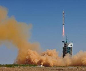 A mapping satellite, "Mapping Satellite - I," is launched from the northwestern Jiuquan Satellite Launch Center, at 3:10 p.m. (Beijing time) on Aug. 24, 2010. The satellite, which was launched on a Long March 2-D carrier rocket, had entered into the preset orbit, according to the center. (Xinhua/Liang Jie) |
 Left: brightness data. Centre: interferometric phase. Right: incoherent areas marked in blue. Credit: DLR. |
 Nagpur, India: Using remote sensing imagery in a unique way, a scientist at the Maharashtra Remote Sensing and Applications Centre (MRSAC), India, has located two burial sites of about 3000-3500 years back. Junapani, one of these megaliths (large stones), found 9 km far from the Nagpur city. Though, the site is known to the archaeologists, it has last been mentioned in the Nagpur Gazetteer in 1930. There is no mention of the settlement after that in the government’s toposheets.
 South Africa: South Africa and Russia have signed a Memorandum of Understanding (MoU) on collaboration in the area of earth observation. Dr Sandile Malinga, Chief Executive of the South African National Space Agency (SANSA) and Professor Alex Perminov, President of the Russian Federal Space Agency (Roscosmos), signed the MoU.
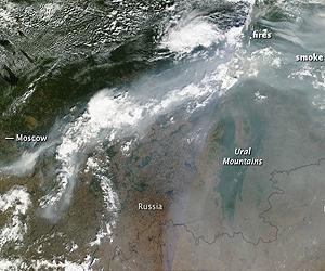 The MODIS instrument on NASA's Terra satellite detected two clusters of intense fires when it acquired a photo-like image. The fires are outlined in red. Credit: NASA Goddard/MODIS Rapid Response Team, Jeff Schmaltz |
 File image. |
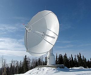 On 10 August 2010, the German Aerospace Center (DLR) inaugurated its first satellite data receiving station in Inuvik, Canada. DLR will use the new ground station particularly to receive data for the German TanDEM-X satellite mission. Using the large, 13-metre antenna, partner countries Germany and Canada as well as scientists from around the world and other external users will be able to access important satellite data, process and evaluate them. Credit: DLR. |
 WISE completed its primary mission, a full scan of the entire sky in infrared light, on July 17, 2010. The mission has taken more than 1.5 million snapshots so far, uncovering hundreds of millions of objects, including asteroids, stars and galaxies. |
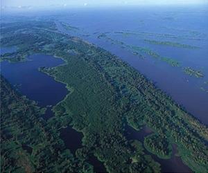 Aerial view of the Brazilian Amazon and Amazon River. Credit: iStockphoto. |
The concentration and global transport of carbon monoxide pollution from fires burning in Russia, Siberia and Canada is depicted in two NASA animations created with data from the Atmospheric Infrared Sounder (AIRS) instrument on NASA's Aqua spacecraft. Image credit: NASA/JPL. View the animation here. |
 The UA's High Resolution Stereo Color Imager, or HiSCI, features an innovative rotation drive for three-dimensional imaging. As the instrument orbits the Red Planet, it snaps pictures once a feature of interest on the surface below comes into view. HiSCI then swings around and takes more pictures of the feature as it passes overhead. |
 Valles Marineris, the "Grand Canyon of Mars," sprawls wide enough to reach from Los Angeles to nearly New York City, if it were located on Earth. The red outline box shows the location of a second, full-resolution image. Credit: NASA/JPL/Arizona State University. The new map is available here |
 This undated photo courtesy of the National Geospatial Intelligence Agency shows Letitia Long. The US government has appointed its first female chief of a major intelligence bureau, with Letitia Long taking over August 9, 2010 as director of the National Geospatial-Intelligence Agency.The NGA is responsible for collecting and analyzing information from satellite imagery and works with the Pentagon and other departments on defense issues, homeland security, and navigation safety. It's motto is "Know the Earth, shows the way." Long has spent more than three decades in military and intelligence fields, beginning her career in the US Navy in 1978. Photo courtesy AFP. |
 UAVSAR interferogram of Southern California near the Mexican border, created by combining data from flights on April 13, 2010, and July 1, 2010. Image credit: NASA/JPL/USGS/California Geological Survey/Google. |
- |
 Spain: The team of Vincent Caselles, professor at the University of Valencia, has developed a remote sensing system for water conservation. Vincent expects that it would save 50% of the global irrigation water. For such innovative work, the World Meteorological Organization (WMO) has awarded the Norbert Gerbier-Mumm International 2010 award to Vincent. The award distinguishes the best scientific article influential in Meteorology.
 Toulouse, France: Astrium has signed a contract worth EUR 55.2 million with the Vietnam Academy of Science and Technology (VAST) for the development, manufacture and launch of an Earth observation (EO) optical satellite system. This follows on from last November’s intergovernmental agreement on space co-operation between France and Vietnam, in which the French government affirmed its commitment to building a closer partnership with Vietnam in the domain of science and technology.
 Karlsruhe, Germany: The potential offered by 3D urban models to cool off cities and towns will be on show at INTERGEO during October 5 to 7, 2010 in Cologne, Germany. “The world's largest trade fair and conference for geodesy, geoinformation and land management is being held under the motto 'Knowledge and action for planet Earth' and is therefore also tackling the challenges of climate change in urban centres,” explained Olaf Freier, CEO of HINTE GmbH and organiser of INTERGEO.
  Lawrie Jordan Director Imagery Enterprise Solutions ESRI |


 Defense News reported that Ofeq-9 will operate "in a constellation with the two other Ofeqs currently in orbit." It said that while precise imaging capabilities remain classified, all offered resolutions that were "much better than a half-meter." |
 disclaimer: image is for illustration purposes only |


